The Landscape Beyond the Highway: Reclaiming the Depopulated Villages West of Jerusalem
By Mira Idries
June 2023
“To all the travellers of this precious homeland,
Who walked, and continue to walk its surface,
Desiring to learn all its phenomena.”[1]
During the Nakba in 1948, Zionist attacks resulted in the depopulation of thirty-eight villages in Jerusalem’s vicinity alone, among them Ein Karim, Qalunia, Sataf, and Al-Qastal.[2] Imwas, Yalu, and Beit Nuba, were among the villages destroyed during the second wave of depopulation, which occurred in 1967. This essay is about lost landscapes, reimagined and reclaimed in the present. Loss, as much an emotion related to the past, resides in the present, emerging into the spatiality of everyday life.
In this essay, I explore how Palestinians’ everyday mobility is a way to reappropriate colonial infrastructures and reclaim colonised landscapes. As depopulated villages west of Jerusalem were transformed into Israeli tourist and recreational attractions, Palestinian Jerusalemites carried out alternative recreational and pedagogical tours, portraying one dimension of their spatial resilience in a city defined by exclusionary infrastructures and planning. By tracing trips from Palestinian residences in eastern Jerusalem to these depopulated villages and examining related urban practices (such as driving, walking tours, and learning Hebrew among others), I uncover skills by which Palestinians subvert infrastructural violence and reappropriate colonial infrastructures.
While spatial resilience of Palestinians took different forms throughout history, the discussion here will focus on contemporary urban reality by examining the ‘colonial present’[3] and challenging discourses that normalise ‘East Jerusalem’ as the only geographical reference to study the lives of Palestinian Jerusalemites, neglecting the historical and contemporary relevance of the city’s western side, as well as the Palestinian right to it. I look at the relationship between hegemonic Israeli infrastructures as tools of segregation and confinement, specifically roads and public transportation networks, and the resultant perceptions of distance and space by Palestinian Jerusalemites, often skewed to seem out of reach, foreign, and intimidating.
To critically gauge real distances, we need to observe the city beyond its urban residential centre and the central north-south line which presumably divides the city into eastern and western parts. The ‘beyondness’ I suggest here is a re-conceptualisation of the city through Palestinians’ contemporary practices of mobility which subvert the hegemonic infrastructures. The ‘beyondness’ we seek here is a space created through mobility and memory; a temporal ‘space of intervention’ as Homi Bhabha calls it.[4]
My broader research focuses on the two depopulated villages of Sataf and Imwas, constructing a historical reading of their landscapes as an integral constituent for understanding their connection to infrastructure. I will however limit my discussion here to brief moments from my on-site research and encounters with Palestinians conducting recreational and pedagogical tours.
The Landscape beyond the Highway: Perceptions of Jerusalem through hegemonic infrastructures
It goes without saying that one of the pivotal moments in Jerusalem’s history is the occupation of its western side in 1948 by Zionist militias, which resulted in the creation of two physically separated entities within the previously united Arab city; ‘East Jerusalem’ under Jordanian rule, and the occupied ‘West Jerusalem’ under Israeli rule. This changed when Israel occupied eastern Jerusalem in 1967, annexing it to the Israeli side and launching a wave of mass expropriation of Palestinian lands, which became the sites for illegal Jewish settlements. Since then, the Israeli state continued to expand the city’s municipal boundaries, prompted by the political aspiration of Jerusalem as a “Jewish city” and the related policies of expulsion, exclusion, and confinement of Palestinians. This expansion is mainly characterised by the annexation and expropriation of vast areas of Palestinian land, while creating physical borders, such as walls and checkpoints, roads and highways, Israeli settlements and protected green areas, to exclude as many of the Palestinian population as possible. For the scope of this paper, it will not be possible to discuss how different borders and boundaries serve Israeli State plans of annexation and segregation to establish a “Jewish city” and confine the demographic growth of the Palestinian population to small areas, therefore I will limit my discussion to Palestinian mobility within the centre of Jerusalem and the neighbourhoods surrounding it.
With both sides of the city occupied, Palestinian Jerusalemites regained access to the occupied western part of the city, albeit conditional on the constraints of Israeli infrastructure. The status of Palestinians, the majority of whom lived in the eastern part, became that of ‘permanent residents’, a status that does not legally consider them citizens of their city. For them, eastern Jerusalem became an open, marginalised form of enclosure. This is most evident in the exclusionary urban policies, often described as ‘ethnocratic’,[5] which confine Palestinians to ‘increasingly crowded neighbourhoods’,[6] with only 13% of their annexed lands designated for construction.[7] This percentage includes already built-up areas.
In this context, the relationship between hegemonic Israeli infrastructures and perceptions of distance and space in Jerusalem can be understood by examining the nature and logics of roads and public transportation. As numerous studies have shown, Israeli roads in Jerusalem function as tools of segregation and exclusion. The distribution of these infrastructures derives from the British Mandate’s tradition of planning Jerusalem according to Western principles’.[8] The main Israeli road network, planned to create bypass roads between Israeli settlements, has created a ‘three-dimensional matrix of roads and tunnels’[9] that cuts through Palestinian neighbourhoods and villages, reducing them to segregated enclaves.[10] Through this deliberate and systematic strategy based on land expropriation and expansive road infrastructures, Israel redrew the city boundaries creating a new sprawling entity known as ‘Greater Jerusalem’.[11] This new Israeli-defined metropolitan area, highly depends on cars, tunnels, and highways, and boasts an infrastructural network that guarantees ‘Israeli spatial contiguity’.[12]
The expansiveness of the road network renders Jerusalem a metropolitan car-dependent city of sprawling and ostensibly distant landscapes (figure 1). Simultaneously, this expansiveness provides an opportunity to juxtapose measurable distance with the perception of distance generated through encounters with infrastructures; a distance imagined and nurtured through fear and discomfort.
Public transportation networks in Jerusalem also reinforce the postulation of the ‘divided city’ where two distinct bus networks, converging and diverging at various points, can be defined: a Palestinian bus network confined to eastern Jerusalem connecting its Palestinian neighbourhoods with a limited north-south extension to the checkpoints separating Jerusalem from the West Bank (figure 2), and a large and complex network of Israeli bus lines in the western part.

Figure 1. Map of the road network in Jerusalem, showing Israeli settlements in the city and road connections towards Sataf and Imwas and other depopulated villages in the west. Map and data by Grassroots Al-Quds and ARIJ, n.a. Reproduced by author August 2022.

Figure 2. Public transport network in Jerusalem showing Israeli and Palestinian bus lines and the Jerusalem Light Rail. Map by Jonathan Rokem and Laura Vaughan, ‘Segregation, Mobility and Encounters in Jerusalem: The Role of Public Transport Infrastructure in Connecting the “Divided City”’, Urban Studies 55, no. 15 (November 2018): 3454–73. Reproduced by author August 2022
Additionally, the Jerusalem Light Rail, inaugurated in 2010, which passes through parts of east Jerusalem, ‘significantly contribute[s] to Israeli designs to make its illegal annexation of occupied Palestinian territory irreversible’,[13] as it connects various illegal Israeli settlements in east Jerusalem.
Although recent years witnessed more Palestinians using these Israeli networks, political tensions made safe travel for Palestinians on Israeli transport networks unachievable. These rising tensions, particularly after Israeli settlers murdered Palestinian child Mohammad Abu Khdeir from Shufat[14] in 2014, resulted in counter-attacks against light rail stations in Shufat. The ramifications of this incident included a deepening distrust and avoidance of the Israeli transportation networks. For Palestinians residing in the city’s eastern part, this further increased a sense of remoteness and distance from western Jerusalem.
I return here to the concept of ‘beyondness’ to understand the city in a way that surpasses definitive tracings of its colonial division. This concept helps in addressing landscapes and infrastructures that generate contemporary patterns of mobility beyond Jerusalemites’ urban residential areas and the colonial division along Road 1 where the former Israeli-Jordanian border was historically drawn. Essential in this context is the east-west road network, which comprises a number of highways running through Jerusalem’s western hinterland, including the Jaffa-Jerusalem Road (Route 443)[15] and Highway 50 (Begin Boulevard). I argue that the inspection of the relationship between these ‘hard’ Israeli lines and Palestinian mobility can restore urgency to a question often neglected in the ‘divided city’ paradigm - that of the lost Palestinian villages west of Jerusalem, which have become a series of naturalised landscapes, set beyond exclusionary infrastructures.
Seen in relation to contemporary infrastructures, the depopulated villages of Jerusalem and their landscapes transcend nostalgia. Instead, they are part of a contemporary spatial equation formed by travel and perceptions of distance; a ‘beyond’ that allows us ‘a return to the present to redescribe our cultural contemporaneity’.[16] The historical connection between the road network and Israeli attacks on the western villages in 1948 and 1967 further emphasise their contemporary relation, pointing out the villages’ strategic locations, particularly near the major Jaffa-Jerusalem Road. Their closeness to road networks and their high ecological value made these villages ideal targets for Israeli-colonial acquisition,[17] prompting the Israeli State to create a ‘green belt’ around Jerusalem, in correspondence to Biblical, and simultaneously modern, imaginaries of Jerusalem as a city set ‘apart in the landscape’.[18] The ‘green belt’ around Jerusalem refers to the afforested areas designated as Israeli national parks on the lands of the depopulated villages west of Jerusalem. This, in turn, generated the image of a green ‘Jerusalemite’ landscape beyond Israeli urbanised areas and highways, which will be further explored in the following section.
Villages to Landscapes: Temporality
Walking in depopulated villages evokes unique emotions that are burdened by the cultural, historic, and ecological significance of spaces constantly subjected to and faced with erasure. Walking also bears an ability to trace the past and the present, becoming an embodied knowledge creation methodology. For the purpose of this essay, I conducted several walks in the ruins of Imwas, and in Sataf where a few houses still stand. Driven by the desire to reclaim these villages, my walks took the role of unearthing a history concealed by destruction and afforestation.[19]
Walking thus became an alternative mode of place-finding, against the use of lacking, and perhaps even complicit, navigation technologies. Popular applications, namely Google Maps and Waze, a navigation software originally developed by an Israeli company, omit most references to depopulated Palestinian villages. Instead, they endorse and contribute to the Zionist narrative and toponyms. This motivated me to expand my fieldwork through onsite mapping and sketches to create personal depictions of the landscapes (figures 3 and 4). My fieldwork benefited largely from walk-along interviews with local hikers and researchers in Sataf and Imwas, and as a result, my maps consist of a compilation of layers of contemporary aerial photos, historical maps, and mappings on foot (figure 5). While using documentary practices, these acts of mapping and tracing onsite and on paper aim at constructing an experiential and sensorial knowledge of landscape and history.

Figure 3. View from the Israeli recreational park, Ayalon Canada Park, built over the lands of Imwas. The tourist ‘palimpsests’ can be seen in the expanded Roman spring in the lower terrain, north-east of the former village, and the afforested areas with hiking trails on the higher terrain. Illustration by the author, August 2022.

Figure 4. Visualising Sataf’s terrain: ruins, trees, and dominant roads. The greenery and scenic views of the destroyed village have made it a main recreational destination for Palestinians. Illustration by the author, August 2022.

Figure 5. Process drawings: Layered maps of Imwas showing two compilations of hand-drawn sketches with old and new maps and aerial photos of the village’s location. Sketch and photograph by the author, July 2022.
My walks, scholarly in essence, intersected with various practices and experiences of Palestinians on recreational tours in the depopulated villages. Are Palestinians in this case mere visitors or tourists, owners, or pilgrims paying homage to a lost history? This is a question about the temporality of landscape embedded in the tension between the villages’ past and present, a tension between the history of violence and dispossession on one hand, and their contemporary space of leisure on the other.
Amidst this tension I refer specifically to Palestinian Jerusalemites who do not originate from these villages, whose families did not face expulsion or erasure on these lands, and therefore share a different connection to them. The reason for this is to observe the ‘colonial present’ from a space beyond that of memory and nostalgia. For Rochelle Davis, this nostalgia has framed the village in the Palestinian imagination as a romanticised ideal, especially considering ‘Palestinians’ current status as landless and dispossessed refugees’.[20] The subjects I address here, however, do not necessarily conform to this refugee status, but are still subject to the Israeli strategies of alienation and expulsion. Under these conditions of Israeli-colonisation, a rising mobile lifestyle can be observed, especially amongst middle class Jerusalemite individuals and families. Through this lifestyle, the depopulated villages have transcended their connection to the past and memory, merging into a contemporary landscape that responds and caters to an urgent need for human contact with greenery and openness, becoming a leisurely and liberating infrastructure of sorts.
This reflects more than a romantic longing for an idealised image of the lost agricultural lifestyle or the life ‘before catastrophic change’ that Davis asserts,[21] as it also harshly exposes the contemporary crisis of dwelling in Jerusalem. The stateless status of Palestinians as mere ‘residents’ in their city only intensifies this condition of deprivation, where their access to the afforested and depopulated villages is conditional, posing them - in technical terms - as tourists or travellers, compared to the Israelis who live in the settlements built on the lands of these villages, while also being exclusively offered opportunities of allotment on the razed ‘wild’ parts.
To evoke the image of a ‘tourist’, a term that would be locally frowned upon and deemed belittling to the Palestinian right to the land, is not to impose it or to contradict these local claims. Rather, by eliciting the historical and contemporary relevance of the field of tourism, I attempt to position this relationship with landscape within its affective and contradictory nature - current need versus memory, trauma versus pleasure. In their article Settler Colonialism, Indigenous Cultures, and the Promotional Landscape of Tourism in Ontario, Canada’s ‘near North’, Grimwood et al. argue:
No doubt tourism is often complicit in marshalling settler colonial power, [...] yet research also suggests that tourism holds promise as a means for enabling resistance to settler colonialism.[22]
The authors further argue for the potential within tourism to become a site of disruption of settler colonialism, suggesting indigenous ‘indifference to tourism’[23] to be itself an asset and a sign of a genuine reclamation of land. Such a claim can be very relevant and provocative in the case of these depopulated villages. For while Palestinians have little to no sovereignty over the villages today, making both official Palestinian tourism and architectural preservation extremely difficult or impossible, a subconsciously touristic practice and recreation can indeed become a significant form of resistance. To evoke this connection between the villages and a subtle form of resistant and informal tourism is to attempt to imagine them anew as spaces of future potential rather than static objects for past-oriented archaeology and historiography (figure 6). Imagination and the embodied space of touring thus represent an alternative sphere for reclamation that engages with ‘historical’ landscapes on a performative level, making them part of a contemporary discussion entangled with the city’s daily life and infrastructures.

Figure 6. Reclamation through various media. From the top: poster for the Reconstruction of the Destroyed Palestinian Villages Competition, page and cover of a Palestinian guidebook to hiking trails in the depopulated villages in Jerusalem. ‘Palestine Land Society’, September, 2020; ‘Tracks through Nature Fus-ha Guidebook’, Burj Alluqluq, 2019. Collage by the author, August 2022.
‘Landscaping’: Reclamation and Embodied Knowledge
As the previous section proposes, mobility has become a major counter-strategy of reclaiming the Palestinian right to the land, despite various Israeli attempts of exclusion. These attempts, rooted in planning strategies, have necessarily generated spheres of fear within the city, creating intangible barriers nurtured through urban discomfort and what may be called ‘settler monolingualism’.[24] To approach these issues in this section, I consider the concepts ‘landscape’ and ‘infrastructure’ and their theoretical capacities and relationships. Using this theoretical framework, I examine the role of pedagogical and recreational tours in the subversion of the existing infrastructures, suggesting driving, embodied education, and learning the dominant Hebrew language as ‘infrastructural skills’ that allow Palestinians to navigate through the imposed barriers and distances.
‘Landscaping Infrastructure’[25]
I emphasise the concept of landscape in this paper building on its evocative political and visual connotations. Historically, the concept fascinated and fuelled colonial imaginations, as an inspired representation of its physical counterpart – the ‘land’.[26] This makes landscape an indispensable concept for contemporary studies of settler colonialism, where the struggle is ‘oriented around the question of land’.[27]
Similar connotations can be traced in the modern concept of infrastructure, which, through its permeation with modernist ideologies, has also been undeniably associated with colonial aspirations. The scientific nature that often characterises infrastructure is also a fundamental aspect of the modern technological turn towards reconstructing relationships within cities through engineered landscapes. Equally important is the ultimate functionality of infrastructure providing tangible and intangible services. This particular quality brings forth its active social and cultural significance. As Pierre Bélanger argues:
Infrastructure is not asocial nor is it apolitical. It divides as much as it connects. It is fragmented while remaining continuous. Nor is infrastructure neutral. It excludes as much as it integrates.[28]
Bélanger’s argument is derived from an interplay between the two terms, in which ‘“Landscape” operates“ as Infrastructure”.[29] Through this interplay, he proposes the term ‘landscaping infrastructure’, envisioning landscape as a verb.
In the context of this essay, where encounters with landscapes and infrastructures are characterised by considerable disparities in power and control, mobility and bodily intervention become essential modes of spatial reclamation. Hence, ‘landscaping’ can be employed to indicate the deliberate subversion and reverse appropriation of established infrastructures by colonised people, through an embodied relationship with the land.
Most importantly, since they lack governmental infrastructures, colonised people often resort to informal and collective methods of reclamation. In the following, I will point at various educational and learning channels employed by groups as well as individuals in Jerusalem, which constitute informal modes of landscaping the existing infrastructures, or, to put it more evocatively, to generate infrastructures of their own through travelling.
Infrastructural Skills
The journeys Palestinians make towards the depopulated villages in western Jerusalem take different forms and scales of organisation. Here, I will categorise these trips into, first, small-scale and often informal trips, and, secondly, guided tours planned to accommodate larger groups. It is important, first, to consider these journeys in relation to the corresponding modes of travel utilised in each, essential as they are to the facilitation and configuration of these trips: private cars and private buses, respectively. By examining these forms of travel, I will approach the idea of recreation and its entanglement with pedagogy, arguing that both forms are necessarily informed by conscious and unconscious knowledge of and connection to the land.
The first category comprises informal trips by small groups of individuals and families, who visit the depopulated villages for their picnics and hill-walks, depending on their travels mainly on private cars. The car rides in these cases are an essential part of the journey, considering the inadequacy of the public transportation network and Jerusalem’s planning as a car-based-city. These cases demonstrate the rising importance of the private car for Palestinians in Jerusalem, particularly for young women. While across the globe the meaning of the private car is rapidly transforming due to environmental imperatives, it bears a specific contextual importance within the Palestinian context as an emancipatory tool for persecuted and gendered subjects, arguably resisting the tendency for universal discourse.
Compared to men, whose exposure to spaces in western Jerusalem is more tangible early on in their lives through their participation as unskilled labourers in the Israeli labour market, Palestinian women have less occasions to travel to western Jerusalem and therefore less opportunities to undermine their fear of Israelised spaces.[30] However, more Palestinian women today are actively looking to expand their knowledge of the city towards the west through driving.[31] In many cases, these journeys are motivated by essential needs for education and work, with more Palestinian women joining Israeli educational institutions[32] and a smaller percentage finding limited job opportunities in the Israeli market.[33] For these women, the ability to drive through an assemblage of intangible barriers is a form of liberation. The car, a seemingly protected capsule against the uncertainties and threats of urban politics in the city, is gradually becoming a necessity for what might be loosely called a middle-class lifestyle serving educational and professional purposes, as well as leisure.
Regardless of their purpose, these car travels generate a new embodied knowledge of the city.[34] In the specific case of recreation in the depopulated villages, however, they extend beyond farther and materially harder lines in the city - namely the highways - making driving a particularly important skill to seek recreation, against the lack of adequate infrastructures. According to Amahl Bishara:
Driving entails practical knowledge, and, for Palestinians especially, driving and riding in cars are the foundations for a grounded political analysis.[35]
Travelling to a ‘landscape beyond the highway’ can thus be seen as a matter of overcoming distance. ‘Landscaping’ and negotiating this distance, however, is not only material, but is also a navigation against a fear-ridden perception of the landscape itself. In this sense, driving becomes a mode of decoding an increasingly foreign road system in the same way as one learns a foreign language.
Additionally, the dominance and hegemony of the Hebrew language in Jerusalem has its ramifications on Palestinians’ spatial mobility, naturally more so for women whose spheres of exposure are smaller. Evoking an analogy between language and the spatial configuration of highway networks is not solely metaphorical, for language itself functions as an inducer of fear. Learning the colonisers’ language emerges here as a tool of subverting or even ‘conquering’ the dominant powers’ infrastructural apparatus. ‘Learning Hebrew has changed my travel routes in Jerusalem’, Shaima, a Palestinian vet working at an Israeli clinic near Ein Karim, tells me.[36] Another young woman, Raghad, notes how understanding Hebrew is a safety strategy for Palestinian travellers if any encounters with Israeli settlers or police occur on the road or at parking lots.[37] The Hebrew language hegemony resulting in urban discomfort on the road is coupled by street signs, which use Hebraized[38] street and place names, erasing the original Arabic toponymy, and its corresponding geography (figure 7).

Figure 7. Image of the segment of Highway 1 that extends south of Shufat and towards western Jerusalem. The signposts signal the Hebrew names of highways, including the Begin Boulevard, and the directions towards Israeli settlements. The accompanying Arabic and English texts are re-inscriptions of the same Hebraized names. Photograph by the author, July 2022.
Thus, armed with an adequate knowledge of Hebrew, young women and men seek to create their own spheres of security that facilitate their mobility. In an interview with Bashar Abu Shamsieh, a 29-year old tour guide from Jerusalem, he emphasised the need for Palestinians to learn Hebrew to ‘unlock different resources of knowledge and allow Palestinians to develop a language that has capacity for argumentation and debate necessary for tour guides working in disputed areas’.[39] Bashar’s focus on language is situated in his experiences as a tour guide, having faced incidents of Israeli animosity against himself and Palestinian groups on his tours.[40] The tours guided by Bashar belong to a specific form of organised trips, on which larger youth groups walk or hike together (figure 8). The word tajwal in Arabic, meaning roaming or wandering, is often used to refer to these trips, and to loosely indicate other informal journeys. Guided tours also involve oral historical and informative accounts of the visited sites.

Figure 8. A Palestinian group on tour with tour guide Bashar Abu Shamsieh in Sataf. Photograph from Al-Jazeera.net. Aseel Jundi, ‘Following his father’s steps.. Abu Shamsia, a guide to the secrets and tales of Jerusalem’, 2019. Accessed June, 2022.
Driving and mastery of the Hebrew language have thus become two necessary skills for movement and touring, especially on lone travels. Naturally, such tours acquire a more political nature. For families, recreational hikes and picnics are critical in so far as they introduce children to the histories of the depopulated villages, allowing them to experience ‘diverse and open environments which the city lacks, while learning and feeling more connected to the land’ (figure 9).[41] Such statements reveal a consciousness about the pedagogic aspect of recreation, an essential characteristic that distinguishes tajwal from disengaged or passive modes of tourism. Hence, this form of tourism has generated a very specific form of attachment to the land that corresponds to what Ruth Wilson Gilmore calls a ‘radical consciousness in action’ resolving ‘into liberated life-ways’.[42]
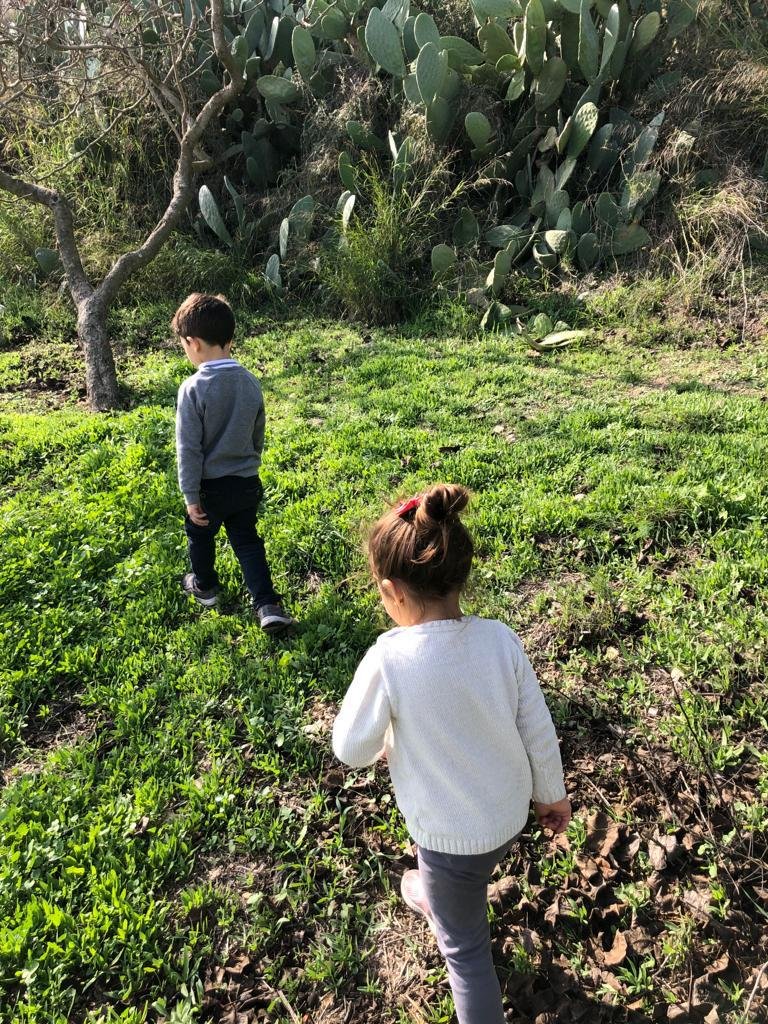
Figure 9. Children playing in Sataf. Photograph by Iba’ Marmash, June, 2022. Personal archive, shared with the owner’s permission.
The building of consciousness, radical or not, is almost always connected to education and to the relationship between generations. My previous analysis shows a deliberate attentiveness to the travels by the young generation and the involvement of children. Although this generation might appear to be the least chronologically connected to the memories of the Nakba and the Naksa,[43] their inclusion in formal and informal tours has proven to be a major step in the construction of a ‘consciousness’ capable of building an indigenous knowledge of history and geography. This leads us to the other major domain where children participate in recreational and pedagogical journeys: the educational system.
As many other sectors in Jerusalem, the Palestinian educational system suffers from ongoing Israeli attempts to control and merge it into ‘Israeli state apparatuses and governmental logics’.[44] This has resulted in the incorporation of many Palestinian public schools in Jerusalem into the Israeli Ministry of Education (IME) and the Israeli Municipality of Jerusalem for funding and supervision. While these schools are allowed to teach the Arabic Palestinian curriculum,[45] this curriculum remains subject to Israeli censorship. This is most evident in the omission and deletion of segments of the original texts, particularly those discussing the history of Palestine and the colonial Zionist aspirations, ‘repressing any form of postcolonial discourse’.[46]
The Israeli attempts to merge the younger Palestinian generation into the norms of the Israeli society are further manifested in the imposition of the Zionist field-education programme known as Shalah and Yidiat Haaretz,[47] in the Palestinian public schools (figure 10). However, the Palestinian rejection of such assimilation and the recognition of education itself as a main site of resistance show the subtle subversion and utilisation of this imposed programme into a Palestinian opportunity to connect with the land.
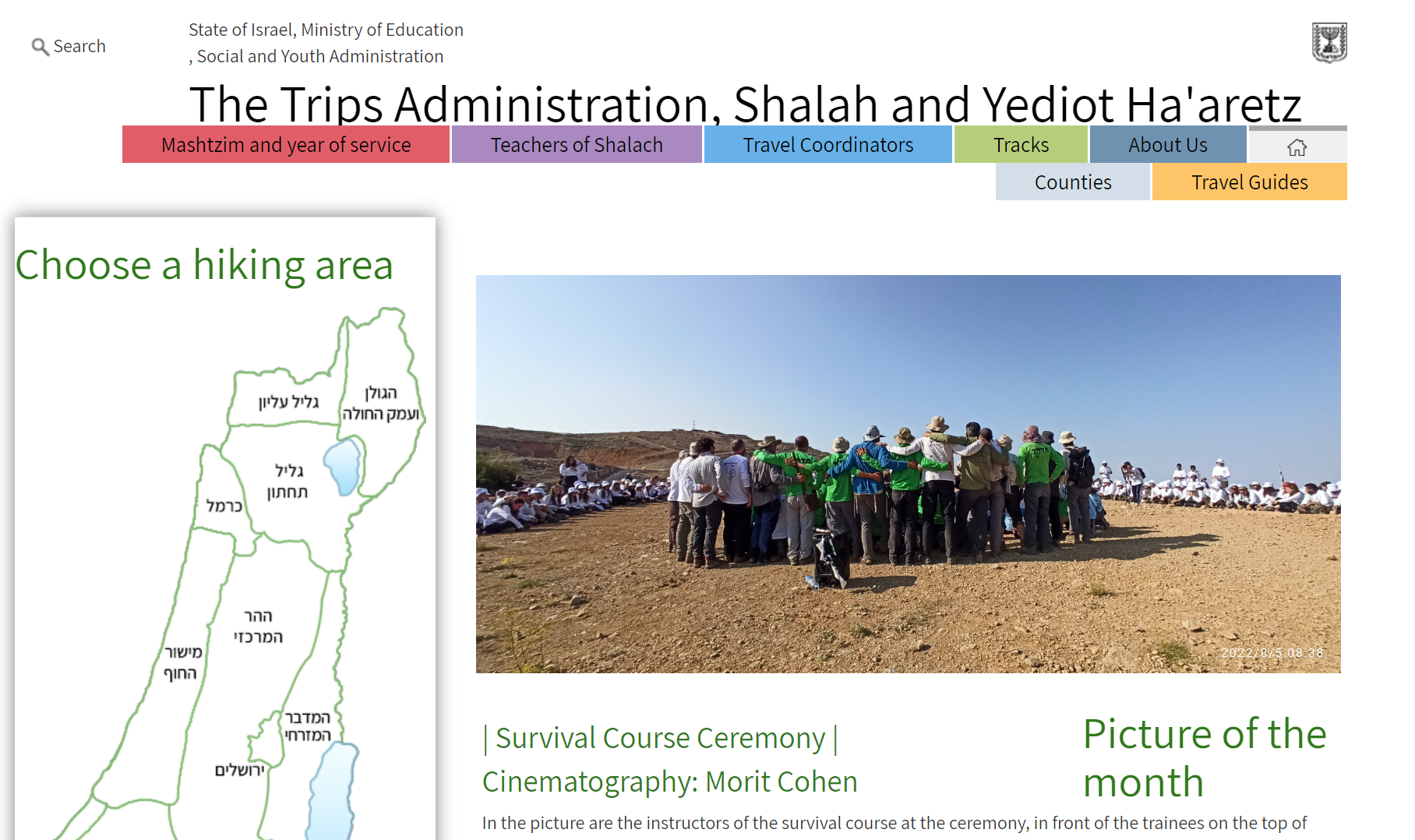
Figure 10. Translated screenshot from the website of the ‘Social and Youth Administration’ within the Israeli Ministry of Education. The original page is in Hebrew. Israeli Ministry of Education, Accessed August, 2022, https://edu.gov.il/noar/tiulim/about-us/Pages/all-about-us.aspx.
According to an official school-trip organiser at a public Palestinian school affiliated with the IME, who requested to remain anonymous and whom I shall call Ahmad, the programme includes two annual obligatory school trips to destinations within Haaretz or ‘the Land of Israel’, referring to the occupied parts of Historic Palestine since 1948, including the depopulated villages west of Jerusalem.[48] Ahmad stresses the sensitivity of his job’s requirements and the contradiction between the agendas behind these trips as designed by the IME and the history and political beliefs associated with these sites for Palestinians.[49]
The execution of the programme in the Palestinian schools, however, does not align with the Zionist programme. As Ahmad explains, Palestinian tour guides and teachers who accompany children on these trips narrate the histories of the destruction, depopulation, and afforestation of the villages. Ahmad’s comments show another level of Israeli attempts at censorship and the persisting threat of labelling Palestinian accounts as ‘incitement speeches’.[50] Other interviewees share similar stories hinting at the complexity of their role as educators in the fields of history, geography, and even biology. Despite enormous challenges, these efforts continue to defy and often subvert the existing systems through tours initiated within and outside the educational system, emphasising the outdoor, rather than the institutional classroom, as a key site of subversion.
Conclusion
I would like to conclude by reflecting on a recurring expression that came up through many of the interviews I conducted - the wish to ‘escape the city to the mountains’ to enjoy nature. An interviewee even suggested that Palestinians are moving from a pedagogy interested in walking ‘to acquire knowledge of the land’, to a contemporary desire to simply ‘walk through nature’.[51] The poetic phrasing raises the question of whether a ‘pure’ form of recreation and escapism, stemming from a mere desire to be close to nature, can be sought within colonial landscapes. This is not to claim that landscapes, colonial or not, can evade the politics of everyday life or that pursuits of leisure within a landscape of immense power asymmetry can be apolitical. Rather, these wishes to disassociate activities typically related to leisure from the emotive tug of loss show a longing for the possibility of an ‘ahistorical’ confrontation with landscape. This is a confrontation where the colonisers’ oppression and its traces in the present cannot inhibit an imaginatively liberatory ‘natural landscape’. Temporary as this wish may be, it is a reminder of the desire to imagine a world where colonisation does not exist:
Challenging the colonial world is not a rational confrontation of viewpoints. It is not a discourse on the universal, but the impassioned claim by the colonised that their world is fundamentally different.[52]
Reimagining a postcolonial world can be recognised as an anticolonial strategy in itself. But I would like to argue that the undoing of colonisation should not be romanticised as the only and ultimate goal of the colonised subject. In other words, the ‘psycho-affective realm’ of colonisation[53] may shape the practices of the colonised, but it cannot override or function in isolation from the subjective and cultural expressions of the body and the psyche. By this I refer to bodily and psychological needs for liberation, not only in a nationalist sense, but also the liberation achieved through seeking physical and psychological shelter and therapy in ‘nature’ away from the modern stifling city. The concept of the modern city with its literally and metaphorically ‘hard surfaces’ is itself a universal product of modernity; nonetheless it is decidedly magnified in colonial settings where the colonised subject is also a subject experiencing colonialism, modernity and the ramifications of their interplay.
The acknowledgement of these aspects is an assertion, on the one hand, of the humanity of the colonised subject, who seeks shelter, nurturance, and nourishment beyond the confines of the colonial reality. And, on the other, it is a reminder to consider the power within desire, whether of play, pleasure, or simply of natural connection, as ‘a cause in the production of social forms’.[54] This power is often obscured in postcolonial discourse where desire is not being adequately stressed as a ‘causal component of agency’.[55] Needless to say, this desire is being nurtured today through social media - a form of immaterial infrastructure itself - where people share their experiences and hikes in the ‘photogenic’ villages through consumable images and videos, that may or may not address the tragic histories of these sites.
Consequently, a desire for recreation can be seen as an incentive for mobility that complements the pedagogical embodied practices previously discussed. Together, these drivers for mobility have contributed to the popularisation of a lifestyle of active leisure for Palestinian Jerusalemites, redefining the perception of a city expropriated by Israeli colonialism. By reclaiming the landscapes of the depopulated villages, Palestinians continue to assert their right to the land, marking their rejection of colonial forms of distance making.
By situating the landscapes of the western hinterland within their past and present realities, I have attempted to emphasise the agency of Palestinian Jerusalemites and the power this agency has to undermine this supposed distance. Reimagining the nature of infrastructure through an active reading of landscape as a verb, this essay has offered a situated perspective on pedagogy and recreation in the Palestinian context, entangled and informed as it is by the politics of everyday life and the hopeful desire to subvert an unjust reality through spatial reclamation and embodied mobility.
Notes
[1] Shukri Arraf, Geographic Sites in Palestine Between Two Eras - Two Maps (Kufr Qare’: Dar Al-Shafaq, 1931).
[2] Walid Khalidi, All That Remains: The Palestinian Villages Occupied and Depopulated by Israel in 1948 (Washington D.C: Institute for Palestine Studies, 1992). 264.
[3] Thomas Philip Abowd, Colonial Jerusalem: The Spatial Construction of Identity and Difference in a City of Myth, 1948-2012, Contemporary Issues in the Middle East (New York: Syracuse University Press, 2014), 5.
[4] Homi K. Bhabha, The Location of Culture, (London ; New York: Routledge, 2004), 7.
[5] Oren Yiftachel and Haim Yacobi, ‘Planning a Bi-National Capital: Should Jerusalem Remain United?’ Geoforum 33, no. 1 (February 2002): 137–44. https://doi.org/10.1016/S0016-7185(01)00024-0.
[6] ‘East Jerusalem,’ B’Tselem- The Israeli Information Centre for Human Rights in the Occupied Territories. Updated January 27, 2019, https://www.btselem.org/jerusalem.
[7] UNOCHA. The Planning Crisis in East Jerusalem, special focus. East Jerusalem: OCHA, April 2009. https://www.ochaopt.org/content/special-focus-planning-crisis-east-jerusalem-april-2009.
[8] Wendy Pullan, “Conflict’s Tools. Borders, Boundaries and Mobility in Jerusalem’s Spatial Structures,” Mobilities 8, no. 1 (2013): 125–47, https://doi.org/10.1080/17450101.2012.750040.
[9] Eyal Weizman, Hollow Land: Israel’s Architecture of Occupation (London ; New York: Verso, 2012), 13.
[10] Eyal Weizman, ‘Principles of Frontier Geography’, in City of Collision: Jerusalem and the Principles of Conflict Urbanism, ed. Philipp Misselwitz and Tim Rieniets (Basel; Berlin; Boston: Walter de Gruyter GmbH, 2006), 84–92; Hanna Baumann, ‘The Intimacy of Infrastructure: Vulnerability and Abjection in Palestinian Jerusalem’, in Planned Violence, ed. Elleke Boehmer and Dominic Davies (Cham: Springer International Publishing, 2018), 137–57, https://doi.org/10.1007/978-3-319-91388-9_8; Pullan, “Conflict’s Tools. Borders, Boundaries and Mobility in Jerusalem’s Spatial Structures”.
[11] Weizman, Hollow Land, 27.
[12] Pullan, “Conflict’s Tools. Borders, Boundaries and Mobility in Jerusalem’s Spatial Structures”.
[13] Omar Barghouti, ‘Derailing Injustice: Palestinian Civil Resistance to the “Jerusalem Light Rail”’, Jerusalem Quarterly File, no. 38 (2009): 14.
[14] Palestinian neighbourhood in the north of Jerusalem.
[15] Also referred to as Mod’iin Road.
[16] Bhabha, The Location of Culture.
[17] Salim Tamari, ‘The City and Its Rural Hinterland’, in Jerusalem 1948: The Arab Neighbourhoods and Their Fate in the War, ed. Salim Tamari, (Jerusalem: The Institute of Jerusalem Studies, 2002), 71.
[18] Shaul Ephraim Cohen, The Politics of Planting: Israeli-Palestinian Competition for Control of Land in the Jerusalem Periphery (Chicago: The University of Chicago Press, 1993), 68.
[19] The Zionist afforestation enterprise in Palestine was launched by the Jewish National Fund (JNF) early in the twentieth century, prior to the creation of Israel. An ongoing nationalist and propagandist means, the project initiated industrious campaigns to plant dense forests of coniferous trees (e.g. pine and cypress), particularly over most of the sites of the depopulated villages after 1948, to cover their remaining traces. See: Noga Kadman, Erased from Space and Consciousness: Israel and the Depopulated Palestinian Villages of 1948, trans. Dimi Reider (Bloomington, Indiana: Indiana University Press, 2015), 140; Cohen, The Politics of Planting: Israeli-Palestinian Competition for Control of Land in the Jerusalem Periphery, 68.
[20] Rochelle Davis, ‘Mapping the Past, Re–Creating the Homeland: Memories of Village Places in Pre-1948 Palestine,’ In Nakba: Palestine, 1948, and the Claims of Memory, by Ahmad H. Sa’di and Lila Abu-Lughod, (New York: Columbia University Press, 2007) 72-73.
[21] Ibid.
[22] Bryan S. R. Grimwood, Meghan L. Muldoon, and Zachary M. Stevens, ‘Settler Colonialism, Indigenous Cultures, and the Promotional Landscape of Tourism in Ontario, Canada’s “near North”’, Journal of Heritage Tourism 14, no. 3 (4 May 2019): 233–48, https://doi.org/10.1080/1743873X.2018.1527845.
[23] Ibid.
[24] Sarah Dowling, ‘Elimination, Dispossession, Transcendence: Settler Monolingualism and Racialization in the United States’, American Quarterly 73, no. 3 (2021): 439–60, https://doi.org/10.1353/aq.2021.0045. [Author’s note: I borrow the term from Dowling’s study, which focuses on the American settler colonial context, utilising intersecting parameters within settler colonial studies].
[25] Pierre Bélanger, Landscape as Infrastructure: A Base Primer (New York: Routledge, 2017), 50.
[26] According to Merriam-Webster Dictionary, ‘land’ usually refers to ‘the solid part of the surface of the earth’, ‘soil’, or simply ‘country’. Merriam-Webster Dictionary, s.v. ‘land’, accessed August 15, 2022, https://www.merriam-webster.com/dictionary/land.
[27] Glen Sean Coulthard, Red Skin, White Masks: Rejecting the Colonial Politics of Recognition, Indigenous Americas (Minneapolis: University of Minnesota Press, 2014), 13.
[28] Bélanger, Landscape as Infrastructure: A Base Primer, 50.
[29] Bélanger, Landscape as Infrastructure: A Base Primer, 24.
[30] Rawan Asali Nuseibeh, ‘Palestinian Women Teachers in East Jerusalem: Layers of Discrimination in the Labour Market’, The Middle East Journal 73, no. 2 (Summer 2019): 207–23.
[31] Based on author observations and interviews with a sample group.
[32] Marik Shtern, ‘Palestinians in West Jerusalem: Economic Dependency Amid Violent Contestation’, Palestine - Israel Journal of Politics, Economics, and Culture 21, no. 2 (2015): 12–17.
[33] Nuseibeh, ‘Palestinian Women Teachers in East Jerusalem: Layers of Discrimination in the Labour Market’.
[34]Amahl Bishara, ‘Driving While Palestinian in Israel and the West Bank: The Politics of Disorientation and the Routes of a Subaltern Knowledge: Driving While Palestinian’, American Ethnologist 42, no. 1 (February 2015): 33–54, https://doi.org/10.1111/amet.12114.
[35] Bishara, ‘Driving While Palestinian in Israel and the West Bank: The Politics of Disorientation and the Routes of a Subaltern Knowledge: Driving While Palestinian’.
[36] Shaima H., personal communications by phone, June 26, 2022.
[37] Raghad A., personal communications by phone, June 17, 2022.
[38] To make ‘Hebraic’ or Hebrew-sounding – related to the Hebrew language.
[39] Bashar Abu Shamsieh, interview by author. July 20, 2022.
[40] Abu Shamsieh, interview, 2022.
[41] Rinad M., personal communications by phone, August 20, 2022.
[42] Ruth Wilson Gilmore, Abolition Geography: Essays towards Liberation, ed. Brenna Bhandar and Alberto Toscano (London New York: Verso, 2022), 280.
[43] The word Naksa in Arabic means ‘setback’, and the term is used locally and in the Arab world to refer to the displacement of Palestinians in 1967 in what is also known as the Six-day War.
[44] Oren Shlomo, ‘The Governmentalities of Infrastructure and Services amid Urban Conflict: East Jerusalem in the Post Oslo Era’, Political Geography 61 (November 2017): 224–36, https://doi.org/10.1016/j.polgeo.2017.09.011.
[45] The Palestinian curriculum is prepared under the supervision of the Palestinian Ministry of Education, based in the West Bank and the Gaza Strip.
[46] Samira Alayan, Education in East Jerusalem: Occupation, Political Power, and Struggle (London: Routledge, 2018), 64.
[47] Short for ‘Field, Nation, Society and Knowledge of the Land’. ‘About us: The Trips Administration, Shalah and Yidiat Haaretz’, Israeli Ministry of Education, Social and Youth Administration, accessed August, 2022, https://edu.gov.il/noar/tiulim/about-us/Pages/all-about-us.aspx.
[48] Interview with an official school-trip organiser, communications by phone, July 28, 2022.
[49] Ibid.
[50] Ibid.
[51] Personal communications with a young female hiker, July 18, 2022.
[52] Frantz Fanon et al., The Wretched of the Earth, trans. Richard Philcox, Revised sixtieth anniversary edition (New York: Grove Press, 2021).
[53] Homi K. Bhabha, ‘Foreword’, in The Wretched of the Earth, by Frantz Fanon et al., trans. Richard Philcox, Revised sixtieth anniversary edition (New York: Grove Press, 2021), 7.
[54] Simone Bignall, Postcolonial Agency: Critique and Constructivism, Plateaus (Edinburgh: Edinburgh University Press, 2010).
[55] Ibid.
Author
Mira Idries is a Palestinian architect and researcher from Jerusalem. In 2022, she was awarded a master’s degree in Architectural History at the Bartlett, UCL, where she focused on issues of landscape, movement, and representation in the Palestinian context. Professionally, Mira worked as a Teaching Assistant at the Architectural Department at Birzeit University, and as an architect in the urban studios IPCC and Housh Studio in Jerusalem.


